For tourists and travel enthusiasts, purchasing a good tourist navigator is an objective necessity. A GPS navigator will always help in assessing the situation, determining the location and choosing the optimal trajectory. This device can greatly simplify life for people who prefer active recreation.
Every year new models of navigators appear on the domestic market, so it is difficult for beginners to figure out which device is best to purchase for hiking. Before you buy a gadget, you should study its characteristics, cost and options.
Tourist GPS navigators: Guide to choose from
Why do we need tourist GPS navigators?
The advantages of a tourist GPS navigator are obvious:
- Speed. You no longer need to waste a lot of time calculating your coordinates and plotting a route;
- Moisture resistant. Can work in snowfall, in the rain, during river rafting;
- Ability to load many maps;
- Additional functions: remembering routes, communication with your phone and with navigators of fellow travelers are never superfluous.
Navigator is different from navigator
Tourist navigators differ from automobile and any other ones in a number of ways:
- Designed to work in extreme hiking conditions;
- Must work for a long time without recharging; the best navigators have power supplies that are easy to replace;
- Compactness, light weight, and ease of use while hiking are much more important than additional functions.
How to choose the best travel GPS navigator
When purchasing a navigator, pay attention to its reliability, map database and navigation capabilities.
I prefer products from trusted brands, the most popular of which is Garmin. The devices of this manufacturer are reliable and durable - they can even be passed on by inheritance. They have many functions that make a tourist’s life much easier, but nothing unnecessary.
The most important thing is the cards. A good navigator should have the ability to update maps for free. Sometimes the manufacturer provides them, but for budget models you have to look for cards yourself.
Another important option is the ability to work with the GLONASS navigation system, which allows you to very accurately determine coordinates.
Don’t forget about autonomy - your hiking navigator should not run out of battery at night in the middle of the forest or during a snow storm in the mountains.
Requirements for navigators for hunters and fishermen
Taking into account the peculiarities of operation, they are understandable, but it would be useful to remind them.
- Increased protection of the “filling” from moisture and dust.
- Mobility, that is, the ability to work autonomously for a long time.
- Light weight.
- Miniature.
- Multifunctionality. As a rule, most hunters are also avid fishermen. Consequently, the conditions in which they have to fish can be very different. That is why it is advisable to purchase a navigator with a large number of options.
Best Bicycle Touring GPS Navigator
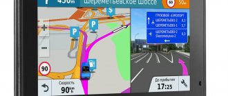
Garmin Edge 820
With a color touchscreen, GLONASS support, and high-quality maps from Garmin, the Edge 820 makes it really hard to get lost while biking. The 2.3-inch screen is small, but it is convenient to mount on the steering wheel next to the flashlight and other accessories. With a price of 28 thousand rubles, the gadget has a lot of useful functions for a cyclist:
- The ability to track the movement of the entire cycling group in real time;
- Current weather information, barometer;
- Communication with other gadgets, notification of calls and messages,
- Bluetooth, Wi-Fi;
- Registration of road accidents;
- Compatible with ANT+ sensors;
- A program for cycling training with recording of dynamics, power, efficiency, stress points.
Waterproof baby weighing only 68g. runs on its own battery for 15 hours - you will have to take care of recharging
| pros | Minuses |
|
|
Price: RUB 27,990
Which GPS tracker is better to buy?
In terms of price-quality ratio, the tourist navigators included in the review were the best in all main criteria. Reliability and stable operation are supported not only by the manufacturers’ assurances, but also by reviews from users who have already tested the devices in practice under real conditions.
To make a choice and understand which one is better to buy, it is enough to analyze which functions and capabilities will become a priority. Inexpensive GPS trackers have basic equipment - accuracy and speed of determining coordinates, reliable protection from external influences of water and dust. The budget affects additional options - there is no compass, few maps in memory. Such devices, according to reviews, are quite suitable for hiking.
Experienced travelers will appreciate the advanced functionality that more expensive participants in the rating have. They not only combine a maximum of additional options, but are also equipped with color screens and have a larger memory reserve. Highly specialized ones are “tailored” to specific conditions of use. Trackers such as the NAVITEL G550 Moto or Garmin Edge 820 are designed with athletes in mind.
To choose the best navigator for travel or recreational tourism, you can take any device from the rating and not worry about quality or reliability. Judging by the reviews, each has the characteristics to ensure safety and accurately follow the chosen route.
The best travel GPS navigator and collar
Garmin Alpha 50 with T5 collar
Do you go hiking with your beloved dog? The Alpha 50 navigator with T5 collar will help you keep your four-legged companion in sight. The navigator with proprietary Garmin software contains built-in maps, but you can download additional ones, including raster ones. With 4GB of built-in memory, it's easy to store a large database. If you want more, use an SD card.
External antennas add sensitivity to the gadget, and support for the GLONASS system accuracy, water resistance allows you to work in dense forests, in the mountains, in the rain or near water bodies. For such powerful equipment, which also monitors the dog, the price of 44 thousand rubles does not seem too high. With a weight of 260 g. The navigator has its own trip computer and Track-Back function. Operates on AA batteries for 20 hours, you can connect an external power source.
| pros | Minuses |
|
|
Price: RUB 67,235
How to choose a navigator
When choosing a GPS tracker, you need to correctly determine its technical characteristics. They must fully comply with the user’s needs, as well as modern requirements that ensure the comfort and safety of the traveler.
Experts include the following main criteria:
- Form factor. There are universal portable models, bicycle, and motorcycle navigators. The first are compact devices that fit in your pocket, others are equipped with special mounts for fixing on a boat, motorcycle or bicycle.
- Coordinate accuracy. Modern models must support GPS and GLONASS; these are the ones included in the rating from our editors. More advanced ones combine them with additional modules, simple ones are limited to basic ones.
- Power type and autonomy. In most cases, trackers are powered by regular AA batteries, this is the most convenient option because spare batteries are lightweight and affordable. Continuous operation time varies from 15 to 25 hours, with a higher figure, as a rule, for simple devices that are not equipped with various auxiliary options.
It is worth paying attention to the functionality; the basic one includes a hunter/fisherman calendar, Track-Back, area calculation, information about the sun and moon, and sound alerts. The navigator must also have a number of pre-installed maps or support the ability to download custom ones.
The best budget travel GPS navigators
Magellan SporTrak
An inexpensive model costing about 6,000 rubles from Magellan is simple and reliable. Nothing extra, but it performs basic functions properly. Compact device weighing 172 g. comfortable to hold with one hand. The device is waterproof and can float on the surface of water. Now the loss of a navigator at the bottom of the river will not be a disaster for the tourist group. Another convenient function is NorthFinder - indicating north. A monochrome LCD screen measuring 3.6 by 5.8 cm and a resolution of 104 by 160 pixels will help save battery. SporTrak runs on two AA batteries for 14 hours: you will need to take a pair of batteries for each day of the hike. The gadget has built-in maps and allows you to download additional ones, but it only has 1 MB of memory.
| pros | Minuses |
|
|
Price: ₽ 6,000
3. Magellan Meridian Gold
Meridian Gold costs about 6,500 rubles, has 16 MB of built-in memory and an SD card slot. Does not sink, can operate at temperatures from -10 to +60 degrees. In addition to the internal antenna, the developers have provided a connector for an external one. The monochrome screen is 4.4 by 5.6 cm and has a resolution of 120 by 160 pixels. The navigator weighs 227 grams. runs on two batteries for 14 hours. It tells you the phases of the moon, the time of sunrise and sunset.
| pros | Minuses |
|
|
Price: ₽ 6,500
Garmin eTrex 20x – best for hikers and hunters
The eTrex 20x travel device is an improved version of the previous model from the Russian manufacturer. The device has improved screen resolution and increased the size of the built-in memory to 3.7 GB. There is a downloaded map of the Russian Federation with a road graph and water load.
GPS-GLONASS receiver with WAAS function and HotFix technology (satellite location forecast) provides fast and accurate calculation of location coordinates. The device does not lose the signal even under dense tree crowns and in deep ravines.
Pros *
- loading BirdsEy satellite images;
- large amount of RAM;
- fast location determination;
- lightweight, fits comfortably in your hand.
Minuses *
- there is no joystick locking function;
- weak GPS receiver;
- There is no screen protection from direct sunlight.
The best wrist travel GPS navigator
Garmin Foretrex 601
A small navigator from the famous manufacturer Garmin works with proprietary software of this brand. The Garmin company is famous for its high-quality maps, which are available free of charge to the owner of the branded device for the entire life of its operation. Foretrex 601 runs on two AAA batteries for 48 hours. At the same time, it supports the GLONASS precision navigation system. The 2-inch screen has a resolution of 200 by 128 pixels, and the body is waterproof.
Additional functions are also pleasing: magnetic compass, barometer, alarm clock, timer, stopwatch, Bluetooth. The gadget can be combined with heart rate, speed, and pedaling sensors. For such options you will have to pay about 12 thousand rubles, but the quality of the device is worth it.
| pros | Minuses |
|
|
Price: RUB 15,497
Garmin GPSMAP 64st – professional navigator for travel
The GPSMAP 64st features a 2.6 diagonal color screen with excellent image quality even in sunlight, as well as a highly sensitive GPS and GLONASS receiver with a quad helix antenna for improved data reception. The device is equipped with loaded “Russian Roads TOPO” maps for hikers and rock climbers.
Users can share routes and tracks wirelessly. Additionally, the device has advanced functionality, which includes a barometer with the function of analyzing weather changes and the ability to notify via email. In addition, the program allows you to download an unlimited number of satellite images.
Pros *
- easily switches between maps and satellite images;
- accurately determines altitude, sunset and sunrise times;
- waterproof, shockproof housing.
Minuses *
- low screen resolution;
- works slowly via USB cable;
- Does not work on lithium batteries.
- high price.
The best premium travel GPS navigator
Garmin Rino 750
This is an excellent navigator, walkie-talkie and even messenger in one package. The 3-inch touch screen with changeable orientation allows you to see the location of all group members. When fellow travelers ask for your coordinates, simply press the PTT key, and the latest data will appear on all devices in the group. The screen quality is quite decent – everything can be seen. Trouble has happened - one press of the Call Key will send an alarm to the entire team. The walkie-talkie works both in normal mode and through a headset. If you can't talk, use text messages.
Rhino 5 can communicate with a mobile phone and display call notifications on the screen. The gadget has 4.5 GB of internal memory plus a slot for micro SD. It runs on its own battery for 14 hours; in the field, you can also connect a cassette with AA batteries. It is compatible with GLONASS and has a three-axis compass and altimeter. For 41 thousand rubles you buy two devices in one. The result is that you carry less weight and free up your hands and space in your backpack.
| pros | Minuses |
|
|
Price: RUB 41,140
Comparative characteristics of models
When choosing a suitable navigator model for hunting and hiking in the forest, comparing the parameters of devices from different manufacturers will help - it is presented in the table:
Choose devices that display as many points as possible; the accuracy of the information received directly depends on this.
- The device must have great functionality and at the same time consume as little energy as possible. This is important because you may not have electricity to charge the device.
- Purchase an additional case for the device, since the seal of the case often suffers during operation.
A GPS navigator is an extremely useful and sometimes irreplaceable device for hunters. In order for the purchased device to best meet the needs of its user, when choosing it, it is necessary to take into account all the important parameters - processor power, memory capacity, availability of cards, level of autonomy and many others.
A navigator for a hunter, fisherman, tourist, as well as a GPS return device for a mushroom picker is a useful and irreplaceable thing. These devices allow you to go deeper into the forest or pass unknown sections of the road without fear. With the device, you don't have to worry about getting lost or lost. The right choice will allow you to travel comfortably through unknown terrain.
When choosing, evaluate the scale of your travels, the remoteness of your hunting grounds and the necessary technical characteristics of the device for this. Purchasing a device that will barely cover your tasks is a bad option. Always choose a more powerful model than the one you currently need.
Comparison table of the best travel GPS navigators
| Name | Main characteristics | Price |
| Magellan SporTrak | Weight 172 g, monochrome LCD screen measuring 3.6 by 5.8 cm and a resolution of 104 by 160 pixels will help save battery. | ₽ 6 000 |
| Magellan Meridian Gold | It has 16 MB of built-in memory and a slot for an SD card, a 4.4 by 5.6 cm monochrome screen with a resolution of 120 by 160 pixels, and a weight of 227 g. | ₽ 6 500 |
| Garmin Foretrex 601 | It runs on two AAA batteries for 48 hours, supports the GLONASS system, the 2-inch screen has a resolution of 200 by 128 pixels, and the body is waterproof. | ₽ 15 497 |
| Garmin Edge 820 | The 2.3-inch screen is small, but it is possible to track the movement of the entire cycling group in real time, Bluetooth, Wi-Fi. | ₽ 27 990 |
| Garmin Alpha 50 | Built-in memory of 4 GB, support for the GLONASS system, waterproof. | ₽ 67 235 |
| Garmin Rino 750 | It has 4.5 GB of built-in memory, a slot for micro SD, runs on its own battery for 14 hours, and is compatible with GLONASS. | ₽ 41 140 |
Best lists
The best travel navigator models are listed below in three categories:
Let's begin a detailed acquaintance with each candidate from the presented list.
For hiking
Garmin Monterra has waterproof firmware and Android operating system. The screen has four inches and an LCD panel.
Cost: from 42,000 to 48,900 rubles.
The most popular question about tourist GPS navigators
What is better to buy: a tourist GPS navigator or a smartphone? Modern smartphones have a GPS navigation function, but they are not suitable for every trip. Only certain smartphone models are protected from moisture, dust and drops on stones. When using a fragile device for navigation on a hike, it can be easily damaged. The second disadvantage is the charging method. Tourist navigators usually operate from autonomous power sources - you can take at least a dozen replaceable batteries on a hike. If spare batteries fail, it is quite possible to buy new ones in the nearest locality.
What to look for when choosing
Tourists, fishermen and hunters cannot boast of a choice of navigators, since they are often replaced with ordinary smartphones and manufacturers simply do not want to work at a loss. However, there are still decent devices on the market, before choosing which it is important to consider the following parameters:
- Type of food. It can be implemented using a battery, replaceable batteries or a power bank. You should choose based on the duration of your hikes.
- Geopositioning systems. In northern latitudes it lays out a route of higher accuracy.
- Screen. The small display, although it causes some discomfort in operation, consumes a small amount of energy and allows the device to have more compact dimensions, since when hiking over long distances, every extra gram counts.
- Control type. Can be touch or push-button. The first will be more familiar to the modern class of users, but it takes up a decent amount of screen space allocated for virtual buttons. The push-button type is considered more reliable because it does not fail after a fall or bad weather, and is considered more reliable.
Komoot
The main advantage of Komoot is the minimum effort required to plan a trip or hike. Once you enter your starting and ending points, the app will create a route using available roads and trails, similar to how a GPS navigator does in a car. This is also available in most other applications, but here there is a detailed description of the level of difficulty of the route and terrain features.
Available for iPhone, Android, Apple Watch, Samsung Gear and Garmin.
Cairn
The Cairn app allows you to share your planned route with your loved ones before you even start your hike. Thus, if you fail to reach your final destination at the specified time, the application will automatically send an alert to your loved ones and report your GPS coordinates.
However, it is worth considering that location updates only occur in areas where there is cellular coverage. The application has a special function that shows in which places on your route cellular communication will be available. If necessary, you can download up to five cards at a time in advance to use them without Internet access.
Unfortunately, the application is not free, but there is a trial period of one month.
Available on iOS and Android.
MapOut
This is a great app for planning a hike if you want to put a minimum of effort into it. The application costs only $5, but its interface is clearer than other applications, which makes it much easier to get directions.
MapOut works with OpenStreetMap maps. They are less detailed than Yandex Maps or Goolge Maps, but are great for walking. There is a function for importing and archiving gpx files (a standard format for laying out walking routes).
Available for iPhone.
Additional equipment
Like all equipment, navigators are equipped with a number of minor options, the need for which is determined by the user. All these functions are undoubtedly useful, but even without them the device will function quite correctly. So how can a manufacturer improve their product?
- Sensitivity of signal reception - most options are equipped with an antenna to better capture the signal in hard-to-reach places (dense dense forest, mountains, caves). Such devices are very bulky, but reliable. Modern models do not have an antenna, but they are all also equipped with a receiver to more accurately capture the signal. There is no particular difference between these products.
- Processor performance – responsible for the performance of navigator services. The more powerful the device, the sooner it will respond to user actions. You can determine the indicator of this option by carefully studying the instructions. However, keep in mind that a powerful processor drains the battery faster.
- Storage capacity – most often, the amount of memory in the navigator allows you to save many maps and routes. And if this is not enough for you, you can always purchase an additional flash drive; a connector for it is available in all modern models.
- Reflective screen - the monitor of modern equipment is treated with a special material that allows you to read all the information under strong light conditions. Thus, the user will not have to go into the settings and adjust the brightness once again.
- Compass - they come in different types. But if you have an analog version of the compass, then you have no reason to overpay for the presence of this addition in the device.
- Barometer - allows you to assess weather conditions and predict their change. Thanks to this, you will be as prepared as possible for any surprises on your trip. And the barometer allows you to determine the altitude if the action takes place in the mountains.
- Camera - of course, you won’t be able to get a high-quality photo, but you can easily remember the area you like, link it to the map, accurately determining the required coordinates.
- Wireless data transmission is directly related to the above function. Using this function, you can transfer photos to another device. If you wish, you can synchronize several gadgets, so the transfer of information will occur automatically.
- Fastenings – if your trip involves riding a bike or bicycle, you cannot do without a special protective fastener.
Advice! Remember that there are now products that can spy on people. They are prohibited for sale and use. Tourist navigators in most cases are not capable of such a function, but before purchasing, do not forget to make sure that the purchase of the gadget is legal.
what3words
It's certainly not an app you should rely on when planning a route in the mountains or crossing wild jungles, but what3words is worth mentioning.
The program was invented by a man who was extremely tired of the fact that couriers could not find their way to his home, located in the countryside of Hertfordshire (England). He developed a system according to which the entire planet was divided into squares measuring 3x3 meters (in the end there were 53 trillion squares), and each of them received a unique identifier consisting of three words.
An amazingly simple idea. It can be used for extremely precise location reference between friends who have no idea what bearing or grid orientation is. It is also used by the publishers of Lovely Planet guidebooks (to indicate the location of attractions) and even in some remote parts of Africa and Mongolia, where often the streets do not have names.
Available for iPhone and Android.